The trails of the Skyrunning European Championship for 2023!
A unique race which whole Europe waits for. The best skyrunners of the Old Continent will try one’s skill, but also everybody who likes this sport. There is an open race for all three distances, with the start delayed 15 minutes after the official European Championship races.
So, here are descriptions, details and applications for all who want to run one of the open races, same as previous years.
Three distances, the new ISF international point system, ITRA/UTMB, also 50% more points for the National League for 2023. Gusinje, July 14–16, 2023 – VK 3,9 km & 1.000 m of ascent, SkyRace 30 km & 2.150 m of ascent and SkyUltra 50 km & 4.400 m of ascent. All races have an international ISF certificate.
The trails and all details are described in the text according to the chain of events (VK Friday – ULTRA Saturday – SKY Sunday).
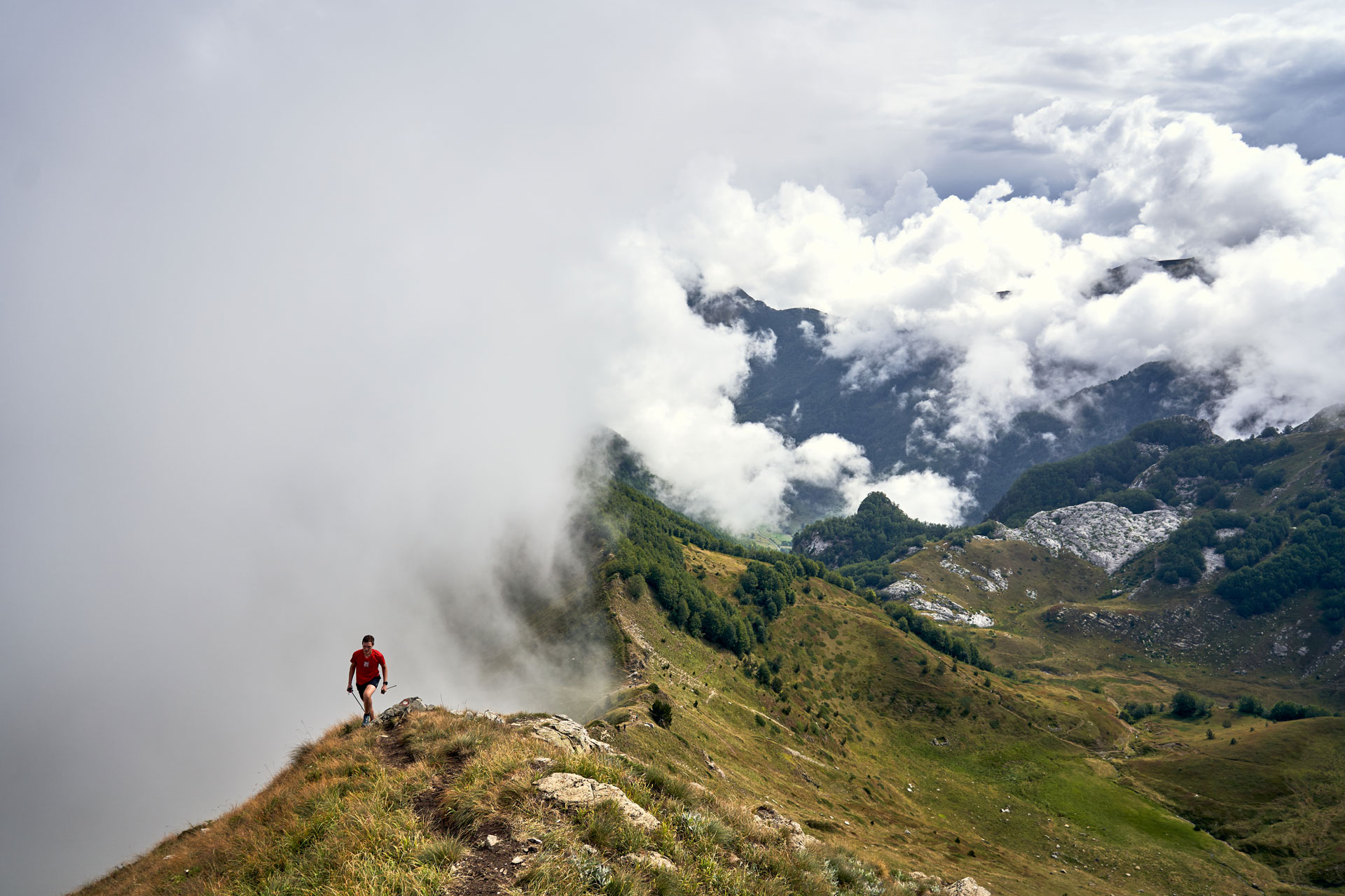
Prokletije VK
A real vertical kilometer, very steep and rocky trail in the most beautiful valley of Montenegro – Grebaja valley. The race which officially opens the Skyrunning European Championship.
Length and altitude difference:
Altogether 3,9 km with 1.000 m of climb. 3,9 km sa1.000 m uspona
Race start:
The start is scheduled on Friday July 14th from Grebaja (Katun Maja Karanfil) 15 minutes after the start of the European Championship race for this format. The start is mass and exact time will be decided by arrangement with the World Association and official protocol and official presenting of all participants’ nations.
Track description:
The start goes from the Grebaja valley (Katun Maja Karanfil) towards Karanfili peaks and stops near the Krošnja pass.
The trail leads you from the Katun Maja Karanfil and you have some 500 m of running along a flat surface (on the trail you have 20 m more of the flat surface, and that’s it, the rest is just climb). Everything will be marked with little flags and ribbons. The start line is visible until 750 m of climb, which gives a special charm to this race – 3/4 of the race is visible from the start line. From the finish line it will not be allowed to move further towards Severni (North) peak of Karanfili, because of the very exposed terrain and the danger of falling. Our people from the race organization will be there and aim you towards the safe direction and the start line.
The famous Krošnja pass took 6 live until now. Please climb these peaks some other time in your own arrangement – and not on the day of the race. The race organizer is responsible for everything what is happening in that part of the Prokletije mountains that day, so we ask you for cooperation and understanding, with the view of safety for all of us.
Very important! Pay attention to the rockslides. The trail isn’t without a danger. So, if you roll down a rock by your foot, you must warn the other runners by shouting: ROCK (in Serbian KAMEN)! Listen out also above yourself, there will be the rockslides for sure. One 300 m section climbs zigzag along hairpin turns and it is very difficult. There will be our people specially to watch every your step. Prokletije require focus and respect on a maximum level. One second is enough for a serious injury. Be careful.
The trail profile and GPX record is impossible to get, because every GPS device reads an error, because you are on a serious vertical terrain. On the top there is NO WATER, so we recommend you to bring water with yourself. On this trail (this race format) there is no aid station. You are completely autonomous. A survival blanket is mandatory, we’ll check it on the top. If it is missing, 10 minutes will be add to finish time. The poles are allowed, but take care strictly not to injure your colleague runners behind you.
Time limit:
The time limit is 120 minutes. We will use photocells, so you’ll get your times with hundredths. Let’s the fastest win!
Prokletije SkyUltra
An extraordinary ultra. Technical sections, long Alpine climbs and downhills. Entering in Albania, crossing peaks over 2.200 m.a.s.l. with a lot of ascents. The trail could get the „The Lord of the Rings“ certificate, because you will go through the rock arches, hundred years old pines, sharp ridges.
Before you enter the kingdom of harsh limestone of Karanfili peaks, the most beautiful panoramic spots towards Popadija and Talijanka peaks, two most beautiful valleys of Montenegro with a grandstand view (Ropojana and Grebaja) there is Bor!
Our GPS record showed even more ascent, bear that in mind!
Length and altitude difference:
Altogether 50,6 km with 4.400 m of climb and downhill. Do we need anything to add when the length and the ascent are compared? Just a little bit easier than Šara SkyExtreme, but for sure more beautiful trail!
Race start:
The start is scheduled on Saturday July 15th 2023, at 7:15 AM from the center of Gusinje.
Track description:
The start is near the Gusinje Municipal building where you immediately turn towards Vusanje and Ali-Pasha’s Springs, then you will branch of before Ali-Pasha’s Springs to the left.
You will go towards Bor on Ćemena peak 2.036. m.a.s.l. There is CP-1 Ćemena (7th km of the race). A control point and an aid station. Downhill towards center of Gornje Vusanje and along winding, alternative roads through the village – and you will reach the base of the race and Eko Katun Rosi. There is CP-2 Rosi (13th km of the race), a control point and an aid station. Further you will continue along narrow paths up rocks and climbing section towards Ali-Pasha Springs.
When you continue uphill, you will find in the forest a spring on the trail itself. That will not be the only spot with spring. Within reach of the summer-pasture mountain camp there is another spring and a great view on surroundings. CP-3 is on the saddle Vezirova Brada (21st km of the race). You have an aid station there. After that you will continue to the Podgoja peak (2.021 m.a.sl.) with magnificent view on Ropojana, Trojan, Albania, Plav… The real terrain starts from there, along the ridge. Your focus has to be on a maximum level. You will climb Mali Karanfil peak (2.119 m.a.s.l.) through the limestone kingdom – you will need your hands in this section of the trail. You will sheer go down below Karanfil Ljuljaševića and Očnjak peaks direct in Grebaja to CP-4 (Katun Maja Karanfil, 27th km of the race). Rich aid station and refill of water in Katun, drop bag and lunch. Don’t forget that from there you must have a head lamp. Prepare also warm clothes. The trail leads you beside Branko Kotlajić mountain hut where you will turn in the forest on the best known trail in the Prokletije National Park towards Volušnica, Talijanka and Popadija peaks. In this section you will have the most beautiful views, intensive climb, border trail with Albania and again you will reach 2.000 m.a.s.l. CP-5 is on Popadija peak (33rd km of the race, just control point).
From Popadija peak you will go down to the Popadija summer-pasture mountain camp below Karaula peak (with remains of an old frontier post) where is the aid station (34th km of the race) and water refill. On that spot you will branch of towards Trojan peak towards Albania. At this aid station you have to refresh well yourself with food and water, because longer period you will be without water and aid stations due to inaccessible terrain.
After that you will return to the border path and then to Trojan pass from where tourist come from Lepuša. This section is outstanding – sheer peaks around you and also pines. After first peak (which is the most beautiful) within Trojan ridge you will reach the saddle and from there sharply up until the peak itself. The views are fantastic. The peak itself is 2.200 m.a.s.l. and there will be CP-6 Trojan (40th km of the race, just control point). From there you will go down along the ridge and sections towards Trojan pass (a rock arch, like fairy-tale!). At this section strictly follow flags, from your left side there will be the abyss. Your focus has to be on a maximum level. After the rock arch you will go through talus slope and fantastic slope full of hundred years old pines towards the old frontier post (just foundation remains) and towards Katun Balića. There is 42nd km of the race and marked spring. From there you will slowly go down towards summer-pasture mountain camp K. Bajrovića where is CP-7 Kodra Bajrovića (44th km of the race), a control point and an aid station. From there everything is easier, downhill along macadam road. The section before Gusinje is interesting, through dense pine forest “Šume Rahine”. There will be CP-8 (48th km of the race, just control point). The finish is near Gusinje Municipal building, same as the start. We have to point out that this section from Katun Balića to Gusinje is full of bears and who is afraid should go in the group or wear a bear bell. Along the section from Trojan to Gusinje there will be part of the race organizers and Mountain Rescue Service. We will pay special attention on this section of the trail.
Time limits:
- CP-3 – Vezirova Brada, 21st km, 12:45 PM (5h and 30 min from the start)
- CP-4 – Katun Maja Karanfil, Grebaja, 27th km, 3:15 PM (8h from the start)
- CP-5 – Popadija, 33rd km, 5:45 PM (10h and 30 min. from the start)
- CP-6 – Trojan, 40th km, 8:15 PM (13h from the start)
- Finish – center of Gusinje, 50th km, 11:15 (16h from the start)
Profile, GPX and race map:
Prokletije 30km 2022 SkyRace (2000 points).gpx
Prokletije Vertical km 2023 final.gpx
As you see, the trail is serious. You must have enough water and food with yourself.
Prokletije SkyRace
The real skyrace which requires 100% focus. Technical sections, long Alpine ascents and descents. A crossing over harsh limestone of Karanfili peaks, passing by the most beautiful panoramic spots towards Popadija and Talijanka peaks and you will have a grandstand view of the two most beautiful valleys of Montenegro – Ropojana and Grebaja.
Length and altitude difference:
Altogether 30 km with 2.150 m of climb and downhill. Our record showed even more climb. In order you to know what is about this race, it is enough to know that all 2.150 m of climb are within 15 km of the trail!!
Race start:
The start is scheduled on Sunday July 16th 2023, at 7:15 AM from the center of Gusinje.
Track description:
The start is near the Gusinje Municipal building where you immediately turn towards Vusanje and Ali-Pasha’s Springs. Until the Springs you have 2,5 km and there you enter a narrow path with intensive climb. There is a spring on the trail in the forest. That’s not the only spring on the trail. Within reach of the summer-pasture mountain camp there is another spring and a great view on surroundings. CP-1 is on the saddle Vezirova Brada (6th km of the race). You have an aid station there. After that you will continue to the Podgoja peak (2.021 m.a.sl.) with magnificent view on Ropojana, Trojan, Albania, Plav… The real terrain starts from there, along the ridge. Your focus has to be on a maximum level. You will climb Mali Karanfil peak (2.119 m.a.s.l., the highest point of the skyrace) through the limestone kingdom – you will need your hands in this section of the trail. You will sheer go down below Karanfil Ljuljaševića and Očnjak peaks direct in Grbaja to CP-2 (Katun Maja Karanfil, 12th km of the race). Rich aid station and refill of water in Katun. The trail leads you beside Branko Kotlajić mountain hut where you will turn in the forest on the best known trail in the Prokletije National Park towards Volušnica, Talijanka and Popadija peaks. In this section you will have the most beautiful views, intensive climb, border trail with Albania and again you will reach 2.000 m.a.s.l. CP-3 is on Popadija peak (17th km of the race, just control point).
From Popadija peak you will go down to the Popadija summer-pasture mountain camp below Karaula peak (with remains of an old frontier post) where is the aid station (18th km of the race) and water refill.
From CP-3 there are no more difficult sections, there are mostly wide macadam roads which go down towards Dolja. The section before Gusinje is interesting, through dense pine forest “Šume Rahine”. There will be CP-4 (26th km of the race, just control point). The finish is near Gusinje Municipal building, same as the start.
Time limits:
• CP-1 – Vezirova brada, 6th km, 9:00 AM (1h and 45 min. from the start)
• CP-2 – Katun Maja Karanfil, Grebaja, 12th km, 11:15 AM (4h from the start)
• CP-3 – Popadija, 17th km, 1:45 PM (6h and 30 min. from the start)
• CP-4 – Šume Rahine, 26th km, 3:45 (8h and 30 min. from the start)
• Finish – center of Gusinje, 30th km, 4:30 PM (9h and 15 min. from the start)
Mandatory equipment:
For VK it is already written up in the text. Survival blanket, rain/wind jacket, mobile phone, cup, and a whistle for SKY and ULTRA. Penalties of 30 mins will be applied if any of these is missing. If two or more items are missing, the disqualification will follow. Runners on 50 km must have a head lamp which will be in the drop bag in Grebaja. Beside the head lamp for SkyUltra runners GPS device is mandatory!
We recommend that you have poles, but bear in mind that you cannot leave them at the stops. On the section from Podgoja to Karanfili we recommend you to fix them to your backpack. You will need your hands there. We strongly recommend for SkyRace runners to have GPS with the route of the race recorded! You must be semi-autonomous (water, gels, etc.) All additional information will be presented through the final e-mail and the Race Guide (Prokletije Race Guide 2023) and the technical meeting in Gusinje.
Race packages:
The packages must be picked up in person. Medical certificate is obligatory for SKY and ULTRA, no older than a year. Applications are open until Jun 13th (Tuesday) 2023, 4:00 PM (meaning that the payments have to be regulated by this time).
Within the participant’s package for the VK & the SkyRace runners will get a unique finishers medal and a cotton T-shirt.
Within the participant’s package for the SkyUltra race runners will get a unique finishers medal and an active T-shirt.
Registration fee:
VK – 15 euro until December 10th, after that date 20 euro.
SKY – 25 euro until December 10th, after that date 35 euro.
ULTRA – 40 euro until December 10th, after that date 50 euro.
Applications
trka.rs/events/352/
---
Rules:
Each competitor must wear the bib in a visible place, on the chest or on the belt, on the front, attached to a jacket or a T-shirt, it must not be covered with a jacket! Losing a bib means an automatic disqualification.
The only spot where you can withdraw where we can arrange transport to the finish is CP in Grebaja. For the SkyUltra runners it will be possible also in Popadija summer-pasture mountain camp.
Should you have any complaints, you can contact us at skyrunning.serbia@gmail.com within 48 hours after the race. After this time, no complaints will be taken into consideration.
All Prokletije races bring 50% more points for the season 2023. All formats have an alternative trail (B option) in case of bad weather.
Accommodation:
We recommend you to book as soon as possible hotels, weekend cottages and eco katuns, especially because of the large number of nations coming to European Championship. For the beginning you can contact local TO Gusinje turizam@opstinagusinje.me
Useful information:
- Weather forecast link: https://www.yr.no/place/Montenegro/Other/Popadija/long.html
Awards:
According to and by arrangement with ISF and the European Championship official award ceremony – center of Gusinje. All details will be promptly announced.
---
Prepare yourself for the most beautiful and the most challenging race in the Balkans!
See you on Prokletije!